Home
Weather New York
WeatherRadar
RainRadar
TemperatureRadar
WindRadar
LightningRadar
Weather News
Editor's Pick
Discover the app
Weather widget
Contact us
Apps
Career
    Home / Weather News /

    Snow, gusts, rain, storms & cold on Wednesday

10:00 AM
December 5, 2024

Breakfast Brief
Temperatures plunge more, gusts and snow

There will be mostly benign weather regarding precipitation across much of the nation. However, cold temperatures, which will feel much colder due to the wind, continue to be the big conversation maker across the Northeast, along with the fast-moving snow bands. The Breakfast Brief is published every Monday through Friday at 5 a.m. ET.

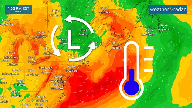
The big news will be the polar cold that will migrate eastward over the Northeast on Thursday. The cold comes with snow showers falling in bands from the eastern portion of the Great Lakes through the Tristate region. NYC will start the day with liquid precipitation, but cold air quickly turns the liquid into snow. The winds will be strong, gusting up to 50 mph at times across the Northeast.

1/2
The WindRadar shows strong gusts as the low pressure swings over the Northeast. Temepratures will feel colder due to the winds.
Winter weather and your petsread more

The low-pressure system, known as the Alberta Clipper, will be moving fast over the Northeast. Expect its center to be out of the region by the evening. Our WindRadar shows that the winds will continue to be strong from the northwest, and although not as gusty, they will remain strong on Friday.

The day will start with rain across the Gulf Coast. The low-pressure system affected Texas and has continued to hug the Gulf Coast, but it is now merging with an incoming cold front. This front will absorb the system, pushing the rain offshore. Rain is coming back for South Texas, but it will be more isolated. Parts of North Florida will receive showers as the front pushes through. These regions have not received rain since Milton, so rain is welcomed!

News we are covering today:

  • Strong gusts and snow for the Northeast.
  • Frigid feels like temperatures
  • Early rain to some Gulf Coast states.

Did you miss these?

When does winter actually begin?read more

App news & updates:

Knowing how much sunshine to expect can make all the difference when planning your day. See how the Weather & Radar Sunlight Hours feature can help.

Irene Sans
More on the topic
Europe: Warmest June on record. Warm waters too. . . Friday, July 10, 2026
The record-breaking heatwave in June has made climate history in Western Europe.
Friday, July 10, 2026

Warm waters too

Europe: Warmest June on record
Record-breaking heatwave in Europe. Hotter than most of U.S.. . . Thursday, June 25, 2026
Thursday, June 25, 2026

Hotter than most of U.S.

Record-breaking heatwave in Europe
Meteorological summer is here!. Bye, spring!. . . Monday, June 1, 2026
Monday, June 1, 2026

Bye, spring!

Meteorological summer is here!
All weather news
This might also interest you
Multi-day rain event ends soon. Southeast U.S.. . . Friday, July 24, 2026
Friday, July 24, 2026

Southeast U.S.

Multi-day rain event ends soon
Intense rain for the Northeast. Flooding possible. . . Tuesday, July 28, 2026
Tuesday, July 28, 2026

Flooding possible

Intense rain for the Northeast
Multi-Day flood threat for Mid-Atlantic. Stalled front. . . Wednesday, July 22, 2026
Wednesday, July 22, 2026

Stalled front

Multi-Day flood threat for Mid-Atlantic
All articles
Weather & Radar

Weather & Radar is also available on

Google Play StoreApp Store

Company

Contact us Privacy policy Legal info Accessibility statement

Services

Uploader

Socials

instagramfacebookthreadslinkList