Weather & Radar
Home / Weather News /

Breakfast Brief: All eyes on Helene

11:38 AM
September 30, 2024

Breakfast Brief
Quiet start for month's grand finale

After the trouble Hurricane Helene brought to Florida and South late last week and massive clean-up efforts continue, the U.S. will get a reprieve from the wild weather to end September.

The WeatherRadar shows the only trouble spot to speak of today will be in the Mid-Atlantic. Upper-level energy from Helene's remnants will spin above, triggering showers with downpours throughout the day. There won't be much break today for Washington and Baltimore, but Philadelphia could see a few break.

A few afternoon showers and thunderstorms will also be possible across northern Florida, these will be widely scattered but could slow the recovery effort after Helene.

Hurricane Season Peaked

With today being the end of September, the peak month of hurricane season will conclude. However, October can produce plenty of tropical actions, so it is best to stay informed.

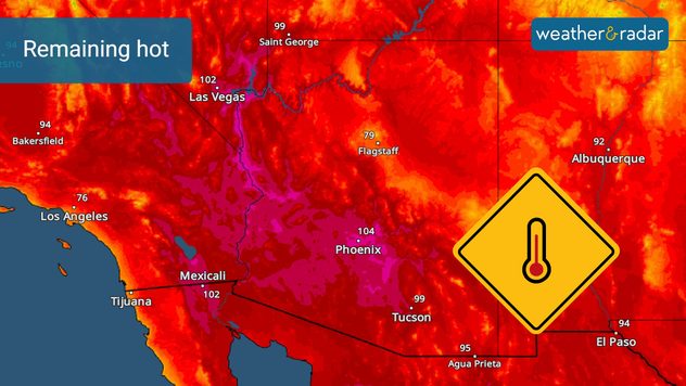
Sunshine will dominate the rest of the U.S. The TemperatureRadar shows unseasonably hot temperatures throughout the Southeast and the interior West from the southern Rockies into the southern and central Plains. Highs in the 80s and 90s will be common with triple digits in the Desert Southwest.

These hot temperatures are 20 to 30 degrees above normal and will possibly set numerous daily temperature records in Phoenix, Las Vegas and Albuquerque, N.M., to name just a few.

Hot Southwest

Our TemperatureRadar does show some autumn temperatures across the Mountain West and the Northwest. Highs will be in the 60s with a few late-day clouds interrupting the sunshine.

The immediate Pacific Coast including Seattle, Portland, San Francisco, Los Angeles and San Diego will be in the 70s as morning clouds linger before sunshine returns.

The rest of the U.S. is quiet today. See the latest forecast on the WeatherRadar.

Tropical update:

There are three systems, Isaac in the north-central Atlantic, Joyce to Isaac's south and Tropical Depression 12 halfway between the Cape Verdi Islands and the Lesser Antilles. Joyce and Isaac are weakening and likely lose their tropical characteristics today. TD12 will grown into a hurricane and possibly major hurricane Kirk later this week. All systems are not not threats to land.

There is also a system being watched in the western Caribbean for additional development. Gulf Coast residents will need to watch this system for additional development over the next week or so.

Be sure to check the WeatherNews section to get the latest information on today's big weather events.

News we are covering today:

  • Helene's clean-up
  • Quiet September end

Did you miss these?

Florida clean-up beginsread more
Helene's destructive legacyread more

App news & updates:

Hurricane season in the Atlantic doesn't end until Nov. 30. Are your hurricane alerts on? Check here.

James West
More on the topic
Sunday, March 30, 2025

Your weather - Your shots

Spring tranquillity across the pond
Man sits with telescope looking up at the Milky Way.
Tuesday, April 1, 2025

April astronomy outlook

A micromoon & the oldest known meteors
easter
Sunday, April 20, 2025

A chance to reflect

Happy Easter to all
All weather news
This might also interest you
Sunday, May 18, 2025

12 years without

EF-5 Drought continues
Thursday, May 15, 2025

Are you ready?

Eastern Pacific Hurricane Season begins
Saturday, May 17, 2025

Incredible video

How do tornadoes form?
All articles
Weather & Radar

www.weatherandradar.com

instagramfacebookthreadsContact uslinkList
Privacy policy | Legal info