Home
Weather New York
WeatherRadar
RainRadar
TemperatureRadar
WindRadar
LightningRadar
Weather News
Editor's Pick
Discover the app
Weather widget
Contact us
Apps
Career
    Home / Weather News /

    Breakfast brief - Midwest to Northeast trouble

10:00 AM
December 31, 2024

Breakfast brief
Midwest to Northeast trouble

The final day of 2024 will be a quiet one for most of the U.S. However, trouble is lurking across the Great Lakes and the Northeast, just in time to flip the calendar to 2025. The Breakfast Brief is published daily Monday through Friday at 5:00 a.m., eastern time.

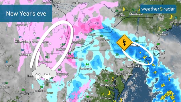
A quick-moving winter storm will streak out of the Great Lakes and the Midwest, moving into the Northeast tonight. The WeatherRadar shows it moving across New York City just before the big drop, but a few thunderbolts could produce rumbles of thunder.

Great Lakes and Midwest will be just cold enough, especially later this afternoon, for wet snow to develop. Chicago, Detroit and Columbus, Ohio, could begin New Year's festivities with a wintry wonderland as temperature drop into the lower 30s.

Across the Rockies, Upper Midwest and northern Plains, the first of several arctic blasts expected over the next several weeks will keep temperatures teens and 20s. Definitely bundle up if New Year's plans take you outside.

It will be a totally opposite story across the the southern Plains, Texas, South and Southeast. Middle to upper 60s will make it a great day to spend outside while Florida and southern Texas hit the middle to upper 70s. Even Washington, D.C., will approach 60 degrees before the sunsets and colder temperatures arrive. Watch for it on the TemperatureRadar here.

California, Great Basin and the Southwest will have a quiet end to 2024 too. A sun-filled day will send temperatures into the 60s from southern and central California to the southern Rockies while the Great Basin will be chillier. Highs in Salt Lake City will be in the 30s while Las Vegas will near 60 degrees.

OTD: San Francisco snow

On this day in 1882, 3.5 inches fell in downtown San Francisco. This is a rare event due the city's close proximity to the mild influence of the Pacific Ocean. 

The Northwest will see waves of clouds and sunshine as a Pacific storm spins just offshore.

News we're covering today:

  • New Year's Eve preview

Did you miss these?

Avalanche threat in Utahread more
Rockies stay snowyread more

Heading to the slopes for the New Year. See what resorts are nearby and view their open status, snowpack and more on the app!

James West
More on the topic
Record-breaking heatwave in Europe. Hotter than most of U.S.. . . Thursday, June 25, 2026
Thursday, June 25, 2026

Hotter than most of U.S.

Record-breaking heatwave in Europe
Super Typhoon Bavi threatens Taiwan. 155 mph winds. . Weather Videos. Wednesday, July 8, 2026
The image shows an intense tropical cyclone over the western Pacific, east of Taiwan and the Philippines. The centre of the system is depicted as a light purple and white vortex with a clearly visible eye, surrounded by a ring of red and orange areas indicating the strongest wind speeds. A white arrow marks the typhoon’s predicted track towards the north-west, in the direction of Taiwan. To the west of the storm lie the Philippines, with the cities of Manila and Cebu; to the north of these lies Taiwan, with Taipei. Further west, the Chinese coast, including Hong Kong, and parts of Vietnam can be seen. The coloured wind map shows predominantly green areas outside the storm’s core, indicating significantly weaker winds. White streamlines illustrate the typhoon’s anti-clockwise circulation in the Northern Hemisphere. The highest wind speeds are concentrated around the eye of the cyclone.
Weather VideosWednesday, July 8, 2026

155 mph winds

Super Typhoon Bavi threatens Taiwan
High pressure & extreme heat. Why & how does it work?. . . Sunday, July 12, 2026
Sunday, July 12, 2026

Why & how does it work?

High pressure & extreme heat
All weather news
This might also interest you
Watch storm clusters interact. A busy WeatherRadar. . . Tuesday, August 11, 2026
Tuesday, August 11, 2026

A busy WeatherRadar

Watch storm clusters interact
The meeting of the wet masses. A Florida story. . . Wednesday, August 5, 2026
Two air masses conerge to produce storms & heavy downpours across the Florida Peninsula today.
Wednesday, August 5, 2026

A Florida story

The meeting of the wet masses
Wildfire smoke on the WeatherRadar. Air quality concerns. . . Tuesday, August 4, 2026
Tuesday, August 4, 2026

Air quality concerns

Wildfire smoke on the WeatherRadar
All articles
Weather & Radar

Weather & Radar is also available on

Google Play StoreApp Store

Company

Contact us Privacy policy Legal info Accessibility statement

Services

Uploader

Socials

instagramfacebookthreadslinkList